

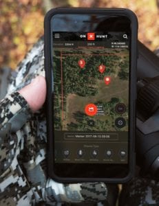
onX, Inc., one of the major players in outdoor mapping technology, has recently released upgrades to their next-generation mapping tool. The latest version of onX Hunt app represents the best available technology in recreational mapping. It includes new layers for understanding animal movements, detailed and accurate land ownership information, and offline usage. The idea is for the new app to offer an unprecedented amount of detail, and it should transform how hunters and outdoorsmen experience the Great Outdoors.
From onX
“With today’s release, onX is taking digital mapping to the next level. We’re ensuring that every outdoorsman and woman can access the most complete and accurate maps possible, and by partnering with well-known hunting organizations, we’ve made more information available to our customers.”
-Eric Siegfried, CEO at onX, Inc.
About onX Hunt App
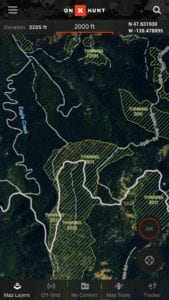
onX has teamed up with many outdoor organizations to come up with an impressive list of new and helpful features. As of right now, onX Hunt app includes onX’s new Topo Basemap. onX’s 20 person GIS team has been out in the field for the last 5 years. They have been compiling data on every trail and 2-track in the United States. Hill shading, contours, and geographical features have been integrated into the app to help users better orient themselves. onX plans to continue to update the map every year.
Layers
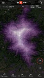
The improved Hunt app also features Randy Newberg’s Roadless Layer. Through a longstanding relationship with professional hunter, Randy Newberg, onX has created a layer within the app to help deep woods hunters get deeper into the backcountry. A heat map highlights areas that exist apart from roadways.
Another layer in the app highlights areas where there have been historic wildfires. Animals will enter recently burned forests as new growth emerges. It includes the fires’ names, year of the fire, and number of acres burned.
onX includes a layer to highlight areas that include thinned out areas of the forest. The USFS Timber Cuts Layer displays logging operations on National Forest Land from 2002 to the present. Also, the app includes a Prarie Dog Layer, which displays satellite imagery of existing prairie dog towns in the United States.
Upcoming Features
Coming soon, onX Hunt app will include Boone and Crockett Records. Joining with North Americ’s oldest wildlife and habitat conservation organization, onX will eventually include a layer that provides information on trophy records by species and county for all 50 states.
In addition to all this, the onX Hunt app can function offline. Customers can choose to save large sections of maps to their phones for use when they hunt out of range from cell towers. Find out more information on the onX Hunt app here.
onX Hunt App Features
- onX’s New Topo Basemap: onX spent more than 5 years compiling every trail and 2-track in the United States
- Boone and Crockett Records: This layer provides B&C information on trophy records by species and county for all 50 states.
- Randy Newberg’s Roadless Layer: onX continues their long-standing relationship with Randy Newberg to create a layer for those hunters who want to go deeper into the backcountry. This map highlights areas that are the furthest away from roads using heat imagery.
- Prairie Dog Layer: onX spent five months poring over satellite imagery to create the most comprehensive map of existing prairie dog towns in the U.S. – over 16,000 in total.
- Historic Wildfires Layer: Hunters have known for years that animals will enter recently burned forests, especially as new growth emerges. This layer presents areas hit by wildfires, including the fires’ names, year of the fire, and the number of acres burned.
- USFS Timber Cuts: This layer is perfect for hunters looking for clear cuts or thinned areas of the forest. It displays logging operations on National Forest Land from 2002-2017.
